
Tateyama Kurobe Alpine Route: Hiking Trails from Murodo
Where to walk on the Tateyama Kurobe Alpine Route, from easy loops around Murodo to the climb up Oyama, plus the snow wall, seasons and what to pack.
May 4, 2026·✍️ olablog·⏱ 6 min read
Where to walk on the Tateyama Kurobe Alpine Route, from easy loops around Murodo to the climb up Oyama, plus the snow wall, seasons and what to pack.
Tap a region to browse articles
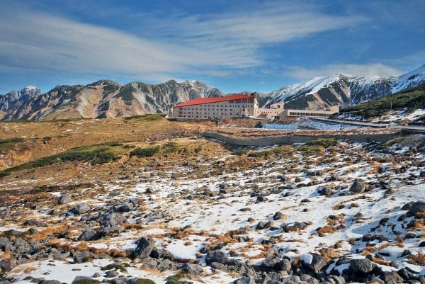
Most people cross the Tateyama Kurobe Alpine Route in a single day, riding a chain of cable cars, buses and a ropeway through the Northern Alps between Toyama and Nagano and stepping off only for photos. That is a fine day out, but the route is also one of Japan's easiest ways into real high-mountain walking. At its highest stop, Murodo, you are already at about 2,450 m, surrounded by crater lakes, volcanic vents and peaks of around 3,000 m. This guide is for those who want to get off and walk.
How the route fits together
From the Toyama side, the Toyama Chiho Railway runs from Dentetsu-Toyama to Tateyama Station in about an hour. From there the Tateyama Cable Car climbs to Bijodaira, and the Tateyama Highland Bus winds up past the Midagahara plateau to Murodo. Beyond Murodo, an electric bus tunnels to Daikanbo, the Tateyama Ropeway spans the valley without a single support tower, an underground cable car drops to the lake, and you walk across Kurobe Dam to a final tunnel bus to Ogizawa on the Nagano side. Local buses link Ogizawa with Shinano-Omachi Station.
From Tokyo, the Hokuriku Shinkansen reaches both Toyama and Nagano, so you can enter at one end and leave from the other. Private cars cannot drive the route; if you arrive by car, you park at Tateyama Station or Ogizawa.
Walks around Murodo
Murodo is the walking hub, and several short loops start right outside the terminal building.
Mikurigaike. A deep blue crater lake roughly 15 minutes from the terminal on paved and stone paths. A loop around it takes about an hour at a gentle pace and gives the classic view of the Tateyama peaks reflected in the water. Beside it, Mikurigaike Onsen is a mountain lodge with a hot-spring bath, one of the highest in the country.
Jigokudani. "Hell Valley" is a basin of steaming, sulphur-yellow vents below Mikurigaike. Paths into it have been closed for long periods because of volcanic gas, so follow the signs at the terminal rather than an old map.
Raichozawa. A walk down past the edge of Jigokudani leads to a campsite and mountain huts in a broad valley, a good half-day outing that ends with a steady climb back up to Murodo.
A short walk from the terminal, look for the old Tateyama Murodo hut, a preserved wooden lodge from the Edo period that once sheltered pilgrims. Keep an eye out for the raicho, the rock ptarmigan, a protected bird that lives on these slopes and is often easiest to spot on misty days, when it feels safe from birds of prey.
Climbing Oyama
Tateyama is one of Japan's three holy mountains, together with Fuji and Hakusan, and its main summit, Oyama (about 3,003 m), carries a small shrine at the top. The trail from Murodo climbs steadily to the Ichinokoshi hut on the saddle, then scrambles up a rocky slope of loose stones and boulders to the summit. No climbing skills are needed, but it is steep and exposed to the weather. Most fit walkers need around four hours for the round trip from Murodo, plus time at the top. The highest point of the massif, Onanjiyama, is a short ridge walk further on.
Experienced hikers link Oyama with the neighbouring peaks of Jodosan and Bessan into a long loop, with views of the sharp spires of Mount Tsurugi. Snow can lie on the upper trail well into early summer, so ask at the terminal about conditions before you set off.
Lower walks: Midagahara, Bijodaira and Kurobe Dam
Midagahara, a stop on the highland bus, is a high wetland with boardwalks between small ponds known as gaki-no-ta, the "rice paddies of the hungry ghosts". It is ideal when the summits are in cloud.
Bijodaira, at the top of the cable car, has paths through old beech forest and past huge cedars.
Kurobe Dam is worth a stop even if you are not hiking: climb to the observation deck, and from around late June to mid-October watch the water discharge.
A seasonal bus from Tateyama Station runs towards Shomyo Falls, Japan's tallest waterfall at about 350 m, around half an hour's walk from the bus stop.
When to go
The route usually opens in mid-April and closes at the end of November.
Spring (mid-April to June) is snow-wall season. At Yuki-no-Otani, near Murodo, the cleared road runs between walls of snow that can reach around 20 m in snowy years, and you can walk a section of it. Hiking beyond the paved areas is limited while the snow lies deep.
Summer (July and August) is the main hiking season, with alpine flowers and mostly clear upper trails. Afternoon storms are common, so start early and be off exposed ridges by early afternoon.
Autumn colours arrive around Murodo in late September and early October, then move downhill through October. The first snow can fall any time from October.
What to pack
- Warm layers and a waterproof jacket, even when Toyama is hot. Murodo is much colder and windier than the valleys.
- Sunglasses and sunscreen: the high-altitude sun is strong, and the glare off snow is intense.
- Proper hiking boots for Oyama; trainers are fine for the Mikurigaike loop in summer.
- Water and snacks for the trail; food is sold at Murodo and at some mountain huts, but do not rely on buying it along the way.
At this altitude some people feel short of breath or get a headache, so take the first hour slowly. Stay on marked paths: this is Chubu-Sangaku National Park, and the alpine plants are fragile.
Plan your trip
A one-day crossing leaves time for Mikurigaike and not much more. To climb Oyama or walk to Raichozawa, spend a night at Murodo, either at Hotel Tateyama, connected to the terminal, or in a mountain lodge, and you will also have the crater lakes almost to yourself at sunrise. If you are travelling as a group, our guide to Alpine Route group logistics covers one-way transport and luggage forwarding between the two ends.
More from this region — Chubu (Nagano, Kanazawa)
View all →
Hot-Air Balloon in Japan — 5 Minutes Over the Alps at a Surprising Price
2 min · tips
Outdoor Summer Camps for Kids in Japan — Why Parents Pick Hakuba
2 min · tips
One Night in Kamikochi: Choosing Where to Stay and Planning a Two-Day Autumn Itinerary
16 min · tips
What to Eat in Kamikochi in Autumn: Grilled Iwana, Fresh Soba, and Nagano Apples
16 min · tips