
Kumano Kodo Guide: Nakahechi Route, Shrines and Seasons
Planning the Kumano Kodo? How the Nakahechi trail works, getting there from Osaka, the three grand shrines, where to sleep, the best seasons and what to pack.
May 4, 2026·✍️ olablog·⏱ 5 min read
Planning the Kumano Kodo? How the Nakahechi trail works, getting there from Osaka, the three grand shrines, where to sleep, the best seasons and what to pack.
The Kumano Kodo is not a single trail but a web of old pilgrimage paths through the mountains of the Kii Peninsula, south of Osaka and Nara. They all lead to the Kumano Sanzan, the three grand shrines: Kumano Hongu Taisha, Kumano Hayatama Taisha and Kumano Nachi Taisha. Retired emperors and court nobles made the journey from Kyoto a thousand years ago, and ordinary people followed. In 2004 the routes became part of the UNESCO World Heritage site "Sacred Sites and Pilgrimage Routes in the Kii Mountain Range".
Walking it today feels less like a mountain hike and more like travelling on foot from village to village: stone steps under cedar forest, small roadside shrines, hamlets on steep hillsides, and a family-run inn with a hot bath at the end of each day.
The routes, briefly
- Nakahechi. The classic route, and the focus of this guide. It runs inland from Tanabe on the west coast to Hongu, with the best signage, the most places to stay and regular buses.
- Kohechi. A demanding route from the temple mountain of Koyasan to Hongu, crossing several high passes. Best left for experienced walkers.
- Ohechi. Follows the coast south from Tanabe, with sea views and far fewer walkers.
- Iseji. Runs from the Ise Grand Shrine down the east side of the peninsula through Mie Prefecture.
Getting there
- From Osaka or Kyoto: the JR Kuroshio limited express reaches Kii-Tanabe in a little over two hours from Shin-Osaka; pick up maps and bus times at the tourist information centre by the station. Buses reach the traditional starting point, Takijiri-oji, in about 40 minutes and continue inland toward Hongu.
- By air: Nanki-Shirahama Airport has flights from Tokyo Haneda, with buses on to Kii-Tanabe.
- The coast: the Kuroshio continues to Kii-Katsuura and Shingu, the stations for Nachi and Hayatama.
Walking the Nakahechi
Takijiri-oji to Chikatsuyu. From the riverside shrine at Takijiri, the path climbs steeply through forest before levelling out. Takahara, a hillside village with wide views over layered ridges, is a lovely place for a break. Most walkers continue to Chikatsuyu, a valley village with several inns, which makes a full first day.
Chikatsuyu toward Hongu. The next section passes Tsugizakura-oji, shaded by huge old cedars, and the scattered hamlet of Nonaka. The distance to Hongu is long, so many people add a night or skip part of the road walking by bus.
Hosshinmon-oji to Hongu. If you only have one day, walk this last stretch. It is about 7 km, mostly gentle and often downhill, through farmland, small hamlets and forest. At Fushiogami-oji, pilgrims caught their first glimpse of the sacred ground at Oyunohara in the valley below. The trail ends at Kumano Hongu Taisha.
Along the way you pass many oji, small subsidiary shrines that mark the route; many have a stamp box for your stamp booklet. Walkers who have also completed Spain's Camino de Santiago can apply for "Dual Pilgrim" recognition.
The three grand shrines and the hot springs
Kumano Hongu Taisha. Dark wooden halls with cypress-bark roofs, reached by a stone stairway; its emblem is the yatagarasu, a three-legged crow. It stood on the river flats at Oyunohara until a great flood in 1889, after which the surviving buildings were moved to higher ground. Oyunohara is now marked by one of the largest torii gates in Japan.
Kumano Hayatama Taisha. In the coastal town of Shingu, with bright vermilion buildings and an ancient nagi tree in the grounds. Nearby, Kamikura Shrine sits at the top of a very steep stone stairway beside a huge boulder, Gotobiki-iwa.
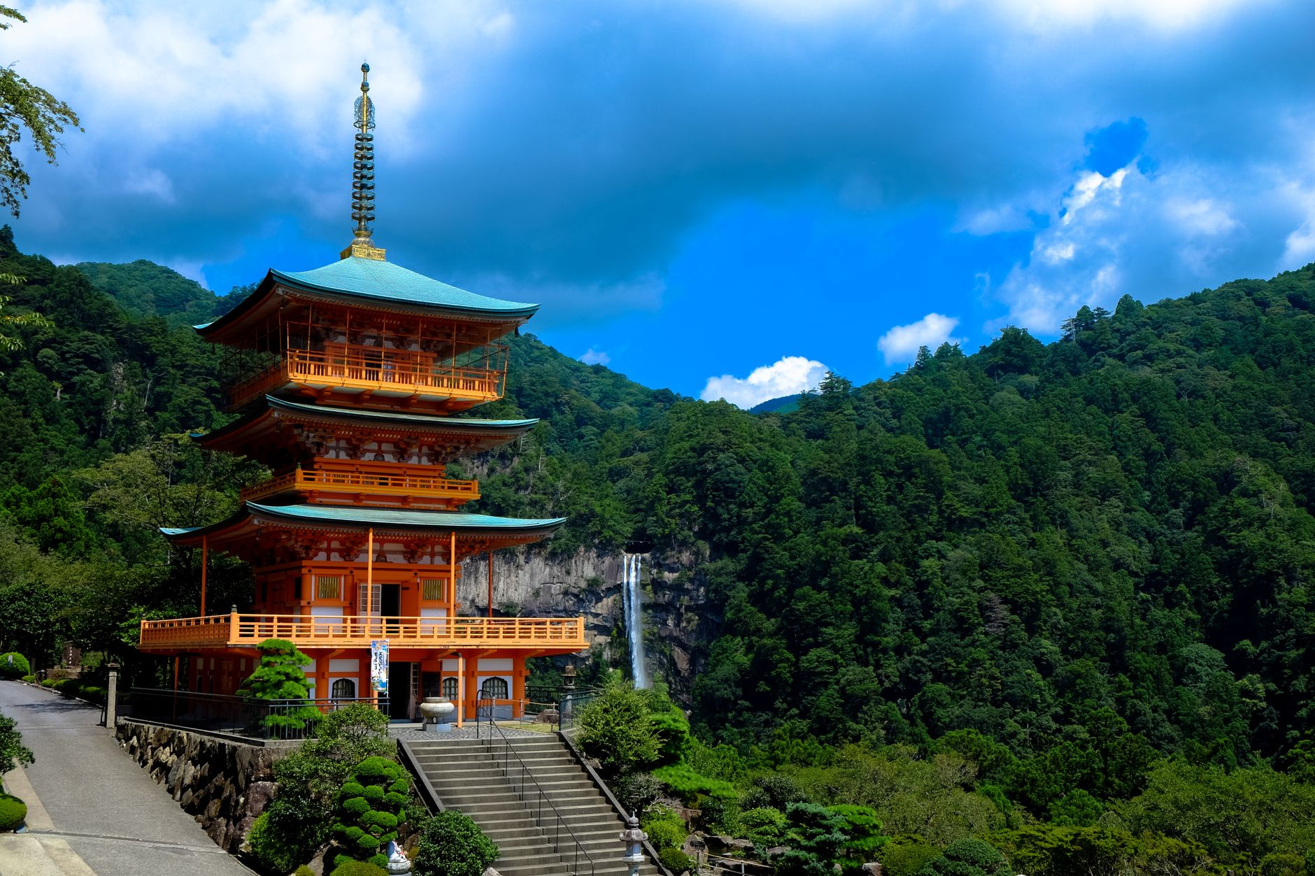
Kumano Nachi Taisha. Set on a mountainside beside Seiganto-ji temple, facing Nachi Falls, which drops about 133 m. The temple's three-storey pagoda with the falls behind is the image of Kumano. Walk up the cedar-lined Daimon-zaka stone stairway rather than riding to the top. Each year on 14 July, the Nachi Fire Festival fills the stone path below the falls with giant torches.
Hot springs near Hongu. Yunomine Onsen has Tsuboyu, a tiny cabin bath often described as the only World Heritage site you can bathe in. At Kawayu Onsen, hot water rises through the riverbed, so you can dig your own warm pool.
When to go
Spring (roughly March to May) and autumn (roughly October to November) are the most comfortable seasons. The Kii Peninsula is one of the wettest parts of Japan, so expect rain at any time. June and early July bring the rainy season, midsummer is hot and humid, and late summer into autumn is typhoon season, when sections can close after storms. Winter is quiet and often clear, but days are short, some inns close, and frost or snow can cover the higher passes.
Practical tips
- Book beds early. Each village has only a handful of inns, and many fill months ahead in spring and autumn. Most serve dinner and breakfast and can pack a lunch if asked.
- Send your bag ahead. Luggage transfer between inns lets you walk with a daypack.
- Wear shoes with real grip. Mossy stone steps and roots are slippery when wet, which is often.
- Carry water, food and cash. Shops are rare between villages, and not every small inn or rural bus accepts cards.
- Start early and know the last bus. The forest gets dark early, and mountain buses are infrequent.
- Show respect at shrines. Bow at the torii, rinse your hands at the water basin and follow photography signs inside the grounds.
Plan your trip
A classic four-day plan: travel from Osaka to Kii-Tanabe and walk from Takijiri-oji to Takahara or, with an early start, on to Chikatsuyu; continue toward Hongu; walk Hosshinmon-oji to Hongu Taisha and Oyunohara, then soak at Yunomine or Kawayu; finally take the bus down to Shingu and Nachi. For section-by-section walking times and a longer look at the Kohechi, see our in-depth Kumano Kodo hiking guide.
More from this region — Kyoto, Nara & Kansai
View all →
Hina Matsuri in Kimono: Doll Displays, Sweets and a Spring Kimono Walk in Kyoto
6 min · culture
Ise Jingu – Japan's Sacred Shrine Deep in a Thousand-Year-Old Forest
6 min · tips
Kimono and a Tea Ceremony in Gion: How a Full Day Fits Together
9 min · culture
Kimono in Kyoto: Where to Wear It, Best Photo Spots and How to Plan the Day
7 min · culture