
Bandai Azuma Skyline: Driving Fukushima's Free Road Through the Sky
Bandai Azuma Skyline, Fukushima's free 28.7 km mountain road topping out at 1,622 m — route facts, highlights, when to go, access and driving tips.
Mar 24, 2026·✍️ olablog·⏱ 6 min read
Bandai Azuma Skyline, Fukushima's free 28.7 km mountain road topping out at 1,622 m — route facts, highlights, when to go, access and driving tips.
Tap a region to browse articles
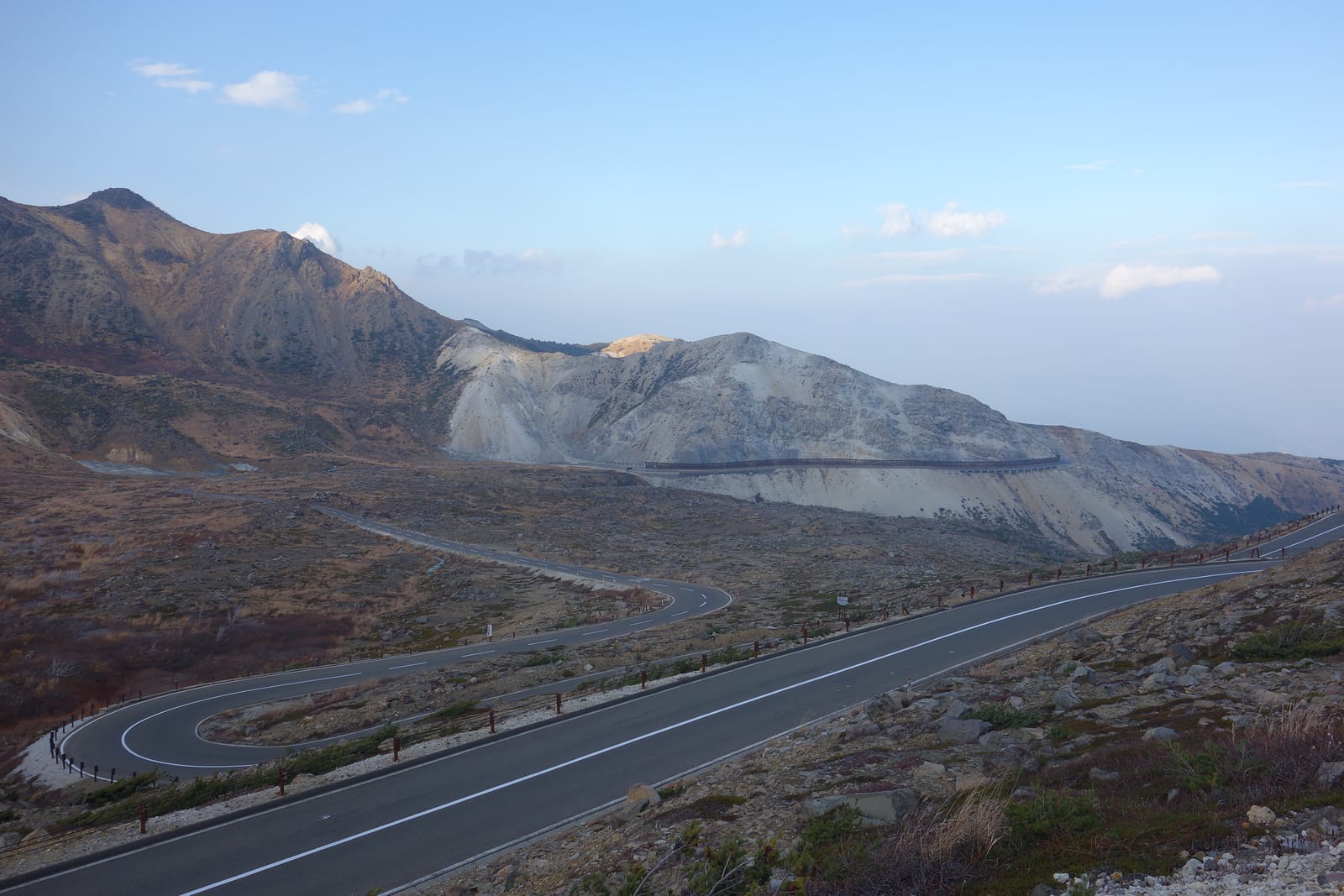
In Fukushima Prefecture, the Bandai Azuma Skyline (磐梯吾妻スカイライン) is a mountain sightseeing road of about 28.7 km linking Takayu Onsen (高湯温泉) with Tsuchiyu Pass (土湯峠). It runs at an average elevation of 1,350 m, tops out at 1,622 m and has been selected as one of Japan's Top 100 Roads (日本の道100選). With scenery on that scale, it fully earns its nickname, "the road that runs through the sky". The road lies within Bandai-Asahi National Park (磐梯朝日国立公園), where terrain shaped by volcanic activity and a landscape that changes with every season keep drawing visitors back.
The Skyline opened in 1959 as a toll road and is often described as Japan's first mountain toll road. After the Great East Japan Earthquake (東日本大震災) of 2011, tolls were lifted as part of efforts to bring tourists back to the region, and since 25 July 2013 the road has been permanently free. Today anyone can drive it on a whim and enjoy the views without paying a yen for the road itself.
1. Route basics
The Bandai Azuma Skyline runs from Takayu Onsen, west of Fukushima City, to Tsuchiyu Pass, winding between the peaks of the Azuma mountain range (吾妻連峰). Driving or riding it is only half the appeal: the scenic spots along the way are made for getting out, stretching your legs and walking or hiking.
| Item | Details |
|---|---|
| Name | Bandai Azuma Skyline (磐梯吾妻スカイライン) |
| Location | From Takayu, Machiniwasaka, Fukushima City, to Tsuchiyu Onsen-machi, Fukushima Prefecture (entrance on the Takayu Gate side) |
| Length | About 28.7 km, from Takayu Onsen to Tsuchiyu Pass |
| Elevation | About 1,350 m on average; 1,622 m at the highest point |
| Tolls | None; the road has been permanently free since 25 July 2013 |
| Setting | Azuma mountain range, inside Bandai-Asahi National Park |
| Recognition | One of Japan's Top 100 Roads |
| Opened | 1959 |
2. Highlights along the road
Three highlights define a drive on the Skyline, and two of them are reasons to leave the car for a while:
- The Azuma-kofuji crater-rim walk (吾妻小富士のお鉢巡り): Azuma-kofuji, the "little Fuji of Azuma", is a volcanic cone with a walk that circles the rim of its crater, known in Japanese as ohachi-meguri, "going around the bowl".
- A stroll through the Jododaira wetland (浄土平の湿原): Jododaira is the place to slow down and walk through high mountain wetland.
- Fudosawa Bridge (不動沢橋): An impressive bridge and one of the most dramatic sights along the route.
Between them, the road itself is the attraction: volcanic slopes, open mountain views and the feeling of driving high above the rest of Fukushima.
3. When to go
The Skyline looks different in every season, and two months stand out: August, when the slopes are in deep summer green and the altitude takes the edge off the heat below, and October, when autumn color spreads across the mountainsides. For photos, aim for early morning or late afternoon (roughly 6:00 to 9:00 and 16:00 to 18:00); the half hour around sunrise and sunset gives the softest light of all.
Whenever you go, remember that this is a high-altitude road. Weather and road conditions can change quickly up here, especially outside the main season, so check whether the road is open and what traffic restrictions are in force before you set out.
4. Getting there
- From Tokyo: Take the Tohoku Shinkansen to Fukushima, a journey of roughly one and a half hours.
- From Fukushima Station: The Skyline is really a road to be driven, so arrange your onward transport into the mountains from Fukushima. A rental car is by far the most practical option: it lets you drive the whole road at your own pace and stop wherever the view demands.
- Where to join the road: The Skyline has two ends, Takayu Onsen on the Fukushima City side (where the Takayu Gate entrance is) and Tsuchiyu Pass. You can drive it in either direction.
✨ Want to drive the Skyline your way? Rent a car with OlaChill and set your own schedule.
5. Planning your drive
The road is only 28.7 km long, but it is not one to rush. Plan a drive from end to end, between Takayu Onsen and Tsuchiyu Pass, and build in time for the stops that make it special: the crater-rim walk at Azuma-kofuji, a walk in the Jododaira wetland and a pause at Fudosawa Bridge. Both ends of the road are hot-spring areas, Takayu Onsen and Tsuchiyu Onsen, so it is easy to start or finish the day with a soak.
6. Practical tips
- Check the road status first: Look up current traffic restrictions and opening conditions on the day you plan to drive.
- Dress for altitude: At an average of 1,350 m, the Skyline is noticeably cooler than the city below, and the weather can turn quickly. Bring a warm layer and rain gear.
- Fill up before you climb: Gas stations are far apart in Fukushima's mountains, so start with a full tank.
- Download offline maps: Signal can be weak in the mountains, so save the Fukushima area in Google Maps before you go.
- Carry some cash: Outside the larger cities, cards are not accepted everywhere, so keep Japanese yen on hand.
Free to drive, high in the Azuma mountains and full of reasons to stop, the Bandai Azuma Skyline is one of the most rewarding mountain roads in Tohoku. Check the conditions, give yourself time for the walks, and let the road set the pace. If you are staying longer in Fukushima, continue to the Goshiki-numa ponds of Urabandai or go underground at Abukuma Cave.
More from this region — Tohoku
View all →
Chartering a 45-Seat Bus in Sendai: A Complete Group Travel Guide
9 min · tips
Hiraizumi: Golden Temples and the Legacy of Northern Fujiwara
8 min · destinations
Kimono in Akita: Where to Wear It, Best Photo Spots and How to Plan the Day
6 min · culture
Kimono in Aomori: Where to Wear It, Best Photo Spots and How to Plan the Day
7 min · culture